 Bruny Island is an island off south east Tasmania. It has a bit of something for everyone, beaches, forests, driving tracks, cruises, holiday shacks, camping, fishing, hiking, restaurants, food and alcohol products. We came over late one afternoon via the car ferry, set up camp ready for exploring the island the next day.
Unfortunately our trip over to Bruny Island was cut short due to bad weather. The thought of leaving the comfort and warmth of our 4WD to brave the cold, wet and windy weather that was plaguing the island was somewhat unappealing. Unfortunately that meant that instead of hiking, sightseeing and relaxing for 2 days we spent a day eating and drinking our way around the island instead, it’s a tough life.
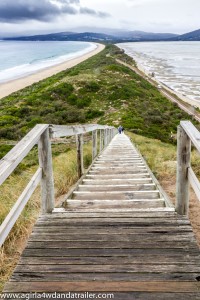
Lookout near our campsite, at the neck.
Places we visited:
Bruny Island Providore
We found this place along the way to the berry farm, It wasn’t listed on the tourist map provided to us so we didn’t know it existed until we nearly drove past it. We did stop in though to sample some fudge and OMG! The fudge is all made by hand from local products, a video was playing in the store, very interesting. We bought some choc mint fudge and kept going.
Bruny Island Berry Farm
Our first stop after leaving Bruny Island Providore was the berry farm. Unfortunately berries are out of season; but, they make sauces and jams when the berries are in season and always have that on hand. We sat down to some real coffee (seriously missing good coffee while travelling) and hot scones, just out of the oven with jam and fresh cream. Melt in your mouth amazingness! I sampled some of their Blackberry sauce and had to buy a bottle to take with me.

Bruny Island Cemetery
Bruny Island Cemetery
This deserves a small mention as this tiny little cemetery had some rather interesting gravestones that I’ve never seen the likes of before. On a few of the graves were these tiny little cement crosses, about 20cm high just sticking out of the ground. The inscription seemed to just be the name of the deceased, strange.
Bruny Island Premium Wines
A lovely café and wine tasting shed on the other side of the island from the berry farm. The Chardonnay and Pinot Noir grapes are grown on the island and the Sauvignon blanc and Riesling grapes are grown in another part of Tas; but, all of the wines are made onsite. The wine was fantastic and I managed to walk away with just one bottle, if that doesn’t show restraint then I don’t know what does!
Bruny Island Cheese Company
I tried a couple of their cheeses at the Salamanca markets in Hobart, very pricey for cheese – $16 each for the 2 I purchased and well worth it! We went through a tasting of 5 cheeses on site and I wasn’t disappointed, the cheese is just sensational. You can eat a load of freshly made goodies onsite but I bought a freshly baked sourdough loaf with my cheese to enjoy later.

Oysters and wine from Get Schucked
Get Schucked
You wouldn’t have thought that I would need lunch at this point; however, there is always room for fresh oysters and wine. The oysters are locally grown and freshly opened which I paired with a glass of Jansz bubbles, felt like I had died and gone to heaven! A dozen naked oysters and a glass of bubble was about $23, bargain!
Bruny Island Smokehouse and Wine bar
And our last stop enroute to the ferry was the smokehouse where a couple of platters of the locally made products (smoked in the back paddock) were waiting for me to taste, yum! We ended up with smoked chorizo pork sausages and hot smoked salmon.
This was the last stop on our foodie / boozie’s tour of Bruny Island, now off to Port Arthur. I would love to come back again to do the hiking, there is always next time.

Drive through the forest in the centre of the south island